The Development
During its operational life (about 40 years), the development would provide capacity to generate up to 20 megawatts (MW).
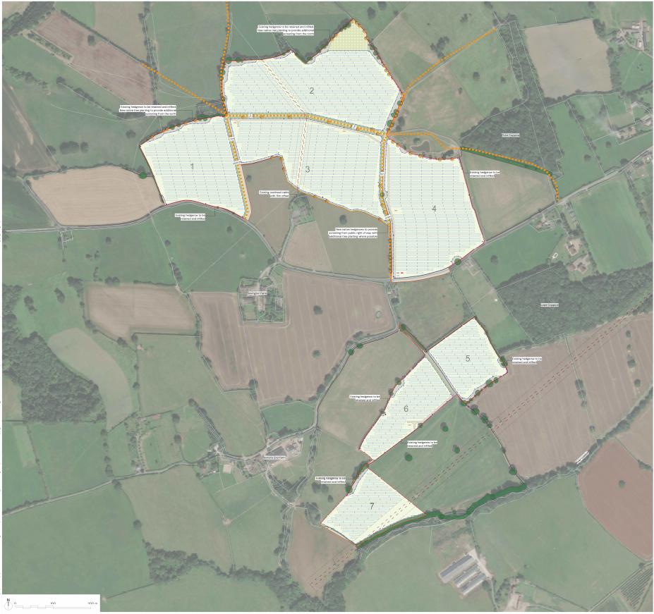
Image shows Landscape Masterplan.
Planning Application Documents
Sinton’s End Solar Ltd have commissioned a technical team to undertake a suite of surveys and assessments, which will be submitted to the Council in support of the Planning Application shortly.
Over the past decade, solar farms have and will continue to become a common feature of the national landscape, with thousands in operation across the country.
The proposed layout has been informed by the Site’s opportunities and constraints and draws on the pre-application advice from Herefordshire Council and the technical consultants instructed by Sinton’s End Solar Ltd. to support with the project.
In regard to the design of the arrays, each of the solar panels will be mounted on a fixed system. The panels will be covered by high transparency solar glass with an anti-reflective coating which minimises glint and glare, whilst also allowing the maximum absorption of the available sunlight. The typical panels are dark grey/blue in color.
The layout will include the following features in respect of landscaping and ecology:
- Species rich wildflower meadows to support pollinators;
- New hedgerow planting and retention of existing hedgerows and tree to ensure consistent visual screening from sensitive receptors;
- Native tree planting to contribute to local green infrastructure;
- The installation of bird and bat boxes; and
- Potential grazing areas for livestock beneath the solar panels.
The final design will be refined to ensure that any impacts are thoroughly mitigated and opportunities for positive enhancement are maximised across the site.
Planning Application Documents
Sinton’s End Solar Ltd. have commissioned a technical team to undertake a suite of surveys and assessments, which will be submitted to the Council in support of the forthcoming Planning Application. This has been informed by the LPA’s Pre-application Advice, as well as the council’s online validation checklist. These include, but are not limited to, the following:
Landscape & Visual Impact Assessment
This will be used to inform and assess the effects of change resulting from development on both the landscape as an environmental resource and on people’s views and visual amenity. The conclusions drawn through this process will inform a landscape mitigation scheme.
Transport Access Statement
This statement describes the effects that the construction phase of the solar farm is likely to have on traffic flows within the local area.
Arboricultural Planning Statement
The purpose of this document is to provide reference and clarification on aspects of tree protection and any necessary tree management works for the proposed development. It is proposed to achieve this by setting out a methodology for all proposed works that may affect trees which are to be retained on and adjacent to site.
Flood Risk Assessment (FRA)
The purpose of the FRA is to establish the risk associated with the proposed development and to propose suitable mitigation, if required, to reduce the flood risk to a more acceptable level. The FRA must demonstrate that the development will be safe for its lifetime (in this case 40 years) taking account of the vulnerability of its users, without increasing flood risk elsewhere.
Preliminary Ecological Appraisal
The aim of the preliminary ecological appraisal and ground level tree assessment is to identify ecological constraints to the proposed works and make recommendations for mitigation or opportunities for enhancement that can be incorporated into the design. The PEA makes recommendations for further surveys, including:
- Breeding bird surveys (including Skylark surveys)
- Biodiversity Net Gain and a Design Stage report
- River condition assessment
Built Heritage Statement
This statement provides conclusions with respect to the significance of the immediate historic environment and the resulting impact of locating the development in this location on said heritage assets and their setting.
Archaeology Desk Based Assessment
The purpose of this report is to describe and assess the significance of potential archaeological remains within the proposed development area. It then provides an assessment of the likely impact of the proposed development, in order to identify potential historic environmental planning constraints.
Agricultural Land Classification Study
This report summarises the findings of an on-site survey in respect to the soil types and agricultural quality of the site, having regard to Natural England’s ALC scale.